Schuylkill River Water Trail
check with the trail manager for updated details before visiting.
Schuylkill River Water Trail
Nonprofit
National Water Trail
- Length
120 miles
- Elevation Gain
490
- Route Type
out & back
- Length
120 miles - Elevation Gain
490 - Route Type
out & back
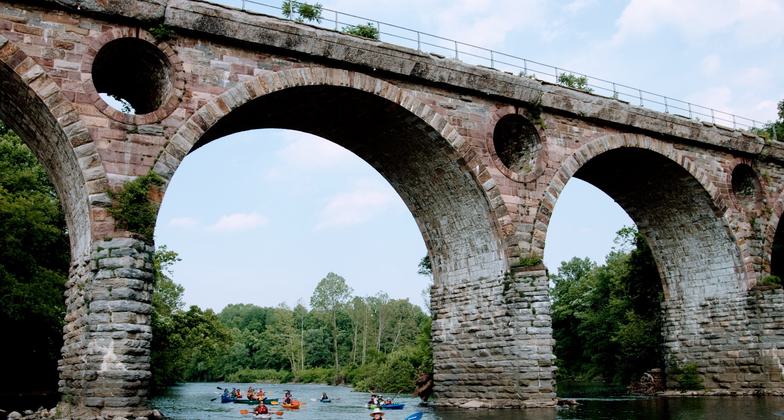
The Schuylkill River headwaters can be found near the tiny coal-region town of Tuscarora, PA and flows southeasterly for over 130 miles through Schuylkill, Berks, Montgomery, Chester, and Philadelphia Counties on its way to its confluence with the Delaware River. The Schuylkill River Water Trail is a paddler’s destination, but other boaters, rowers, and anglers will also find many places to enjoy the Water Trail. From exciting whitewater, to miles long stretches of peaceful smooth flowing river, there is something here for everyone.


Location: The length of the Schuylkill River from Schuylkill Haven, PA to Philadelphia, PA
- States: Pennsylvania
- Counties: Schuylkill, Berks, Chester, Montgomery, Philadelphia
- Cities/Townships: Schuylkill Haven, North Manheim, South Manheim, Landingville, West Brunswick, Auburn, Tilden, Port Clinton, Windsor, Hamburg, Perry, Centre, Shoemakersville, Ontelaunee, Leesport, Bern, Muhlenberg, Reading, Wyomissing, West Reading, Cumru, Lower Alsace, Exeter, Robeson, Birdsboro, Amity, Union, Douglass, North Coventry, West Pottsgrove, Pottstown, Lower Pottsgrove, East Coventry, Limerick, East Vincent, Royersford, Spring City, Upper Providence, East Pikeland, Phoenixville, Schuylkill, Lower Providence, Upper Merion, West Norriton, Norristown, Bridgeport, Plymouth, West Conshohocken, Conshohocken, Lower Merion, Whitemarsh, Philadelphia
When early Dutch explorers first gazed through a dense archway of trees near present-day Philadelphia, they discovered a pristine river flowing quietly into the Delaware River. They named it "Schuylkill," which means “Hidden River” in Dutch. For centuries, people have revered, used, and at times abused the Schuylkill, but it has also undergone restoration that shows its immense value, strength, and beauty. Today, the river remains a hidden treasure for those who paddle its waters or explore its banks. Whether seeking the thrill of whitewater, the serenity of peaceful, sparkling waters, or the chance to spot an eagle or osprey overhead, the Schuylkill offers something for everyone, from the stories of America’s birth to the vital, welcoming communities that line its forested shores.
Known as the “River of Revolutions,” the Schuylkill has played a central role in the American, industrial, and environmental revolutions. The battle for American independence unfolded along the Schuylkill River, with key events occurring in and around the Schuylkill River Heritage Area. At Germantown, Paoli, Fort Mifflin, and Brandywine, the patriot army fought crucial battles against the British. At Valley Forge, a war-torn army endured a brutal winter and emerged stronger in the spring. The surrounding farms and forges provided essential food and supplies, and American history was forever changed in this region.
With the rise of industrialism in the 19th century, the Schuylkill River became a hub for mines, factories, mills, and forges, all powered by the region’s abundant coal and fast-moving waters. Southeastern Pennsylvania became a leader in the Industrial Revolution, with the Schuylkill Canal, built by the Schuylkill Navigation Company, playing a vital role in transporting coal and finished goods. This canal system, one of the earliest in the country, transformed the river and sparked innovations that fueled industrial growth. The success of these industries attracted waves of immigrants, and the region became home to diverse communities, enriching the area with a mix of cultures and traditions.
By the mid-1800s, industrialization had severely polluted the Schuylkill River. Coal operations in Schuylkill County dumped vast amounts of coal silt into the river, and cities along its banks increasingly used the waterway as a dumping ground for industrial and residential waste. This pollution turned the river into an environmental disaster. The City of Philadelphia, which relied on the river for its water supply, recognized the danger to public health and acted. The Fairmount Water Works, constructed in 1812, drew water from the river for the city, but by the early 20th century, the water quality had deteriorated significantly.
In response to the pollution, the state of Pennsylvania and the federal government launched the Schuylkill River cleanup project in 1947. This ambitious project aimed to restore the river’s water quality and prevent further contamination. The government use of the dams and land holdings of the defunct Schuylkill Navigation Company that it had acquired in the 1930s to create large basins where water could settle and allow coal silt and other debris to separate. The water was gradually filtered, and the project was considered the largest environmental cleanup in the world at the time. These efforts not only improved the river’s health but also set a precedent for future environmental remediation projects. Today, the Schuylkill River stands as a testament to the power of restoration, marking a key milestone in American environmentalism.
The Schuylkill River Watershed is the most densely populated region in Pennsylvania. Over 3.2 million people live, work, and play in this 2,200-square mile area (over 1.2 million acres). Almost one-third of the state’s population lives within its boundaries and nearly 25% of the U.S. population lives within a five-hour drive of the Schuylkill. Providing drinking water to almost 2 million people, the Schuylkill River is one of the most significant natural resources for this heavily populated part of our region.
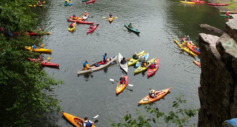
The Schuylkill River Water Trail is a key highlight of the Schuylkill River Greenways National Heritage Area, offering a prime destination for paddlers, boaters, rowers, anglers and other outdoor users, with access to both the river and its nearby lakes and tributaries. Since the early 1950s, the river has experienced a remarkable recovery, supporting a diverse range of fish species including trout, bass, panfish, and even large catfish. The water trail offers a mix of tranquil stretches and more challenging sections, making it ideal for water enthusiasts of all kinds. Beyond paddling, the Schuylkill River Trail (SRT) runs along the river for 75 miles (with plans to extend to 120 miles) and is well-maintained, providing a flat route for walking, running, and cycling. While the SRT offers beautiful views of the river, the water trail remains the main attraction for those looking to enjoy the river up close. In addition to the trail, the Heritage Area boasts a network of local parks, nature preserves, historic sites, and environmental education centers.
Accessibility Information
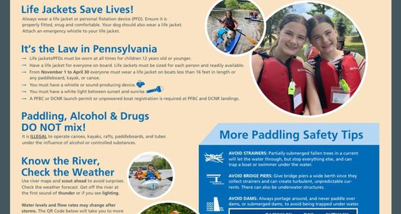
Launch sites designed and constructed by SRG in partnership with state and municipal partners adhere to ADA access compliance. These accessible features include ADA designated parking spots, accessible pathways and ramps with slopes that meet ADA requirements, and in some cases park benches or picnic tables that are specifically designed to meet the bench standards of Chapter 903 of the Architectural Barriers Act. The construction standards of new or rehabilitated launch sites are generally set by federal, state, or local funding sources acquired to complete construction. ADA accessible features is a typical requirement of these funding sources, and a shared goal between SRG and the sponsoring agencies. SRG internally adopted a new or replacement bench policy that requires donations of benches to meet ADA standards. Furthemore, Take It Outdoors (TIO) is SRG’s sister organization and serves as the rivers outfitter. TIO provides equipment for kayaking, canoeing and adaptive kayaking. TIO is a fully insured outfitter that can provide ADA accessible kayaks for individuals with mobility disabilities. The kayak is fixed with a specialized seat and outrigs for enhanced stabilization on the river. An adaptive chair is also available to help individuals with disabilities transfer from the kayak launch to the kayak. TIO guides are certified and trained in the use of the equipment, as well as the care and response of a disabled individual if the kayak were to capsize.
Allowed Uses:
Boating, motorized Boating, human-powered Swimming OtherOther Activities
- Fishing
- Heritage and history
- Wildlife viewing / observation
- Other
Public Contact
Kent Himelright, Trails DirectorSchuylkill River Greenways National Heritage Area
140 College Drive
Pottstown, PA 19464
[email protected] • 4849450200
More Details
- Elevation (low): 526
- Elevation (high): 36
- Elevation (cumulative): 490
- Part of a Trail System? No
- National Designations: " A Paddlers Guide to the Schuylkill River" won the 2017 Highly Commended award from the British Cartographic Society.
- State Designations: Pennsylvania State Water Trail, Pennsylvania Scenic River
- Surface (primary): Water, slow moving
- Surfaces (additional): Water, rapids, Water, swift moving, Water, slow moving, Water, tidal
- Tread Width (average): --"
- Tread Width (minimum): --
- Running length (minimum): --
- Tread Grade (average, percent): --
- Tread Grade (maximum):
- Running length (maximum): --
- Cross-slope (average, percent): --
- Cross-slope (maximum): --
- Running length (maximum): --
- Certified as an NRT
Jun 5, 2026